Hurricane Ida grew fast and is posing a threat to Louisiana. The storm could be a Category 3 or 4 by the time it makes landfall, likely sometime on Sunday. Where is the storm now? Read on to see live radar and maps of the storms.
Live Radar & Video Streams Reveal Ida’s Location
Live radar and maps can help you keep track of Hurricane Ida’s current location and where the storm is moving. The storm is expected to strengthen quickly as it passes over warm water in the Gulf and poses a serious threat to the Louisiana region, Accuweather reported. Louisiana Gov. John Bel Edwards declared a state of emergency. The storm will make landfall on the 16th anniversary of Hurricane Katrina.
This first live radar, embedded below, is from Windy.com. This radar is one of the most helpful for tracking Ida’s location live. You can press the + button on the right side of the map to zoom in more closely. You can also move the map ahead in time to see where the storm is forecast to be headed. Depending on your browser, you might need to click on the map and drag it to see Ida’s current location.
Google also has a live map tracking Ida’s location. Unfortunately, the map is not embeddable.
Another live storm tracker, from NowCoast at NOAA.gov, is here. While the map is not embeddable, it will provide live updates as the NOAA tracks the storm. It’s another good resource for tracking the storm in real-time.
You can also watch videos of live trackers. The video below, from NBC News, is tracking Ida’s location live.
WFAA is also providing live tracking coverage of Ida’s progress.
WWLTV also has a live tracker.
You can also watch live coverage on Fox’s Storm Watch, embedded below.
Ida’s Projected Path
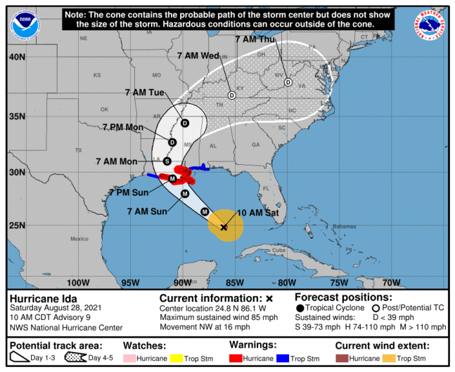
As of 10 a.m. Central on Saturday, August 28, the National Hurricane Center (NHC) provided a map of Ida’s projected path, which you can see above or via the link here. At that time, Ida was located at 24.8 N, 86.1 W, about 350 miles south-southeast of the mouth of the Mississippi River and about 435 miles southeast of Houma, Louisiana.
The National Hurricane Center noted at 10 a.m.:
Ida is moving toward the northwest near 16 mph (26 km/h), and this general motion should continue through late Sunday or early Monday, followed by a slower northward motion on Monday. On the forecast track, the center of Ida will move over the southeastern Gulf of Mexico today and move over the central Gulf of Mexico tonight and early Sunday. Ida is then expected to make landfall along the U.S. northern Gulf coast within the hurricane warning area on Sunday, and then move inland over portions of Louisiana or western Mississippi later on Monday.
Maximum sustained winds are near 85 mph (140 km/h) with higher gusts. Rapid strengthening is forecast during the next 24 to 36 hours and Ida is expected to be an extremely dangerous major hurricane when it approaches the northern Gulf coast on Sunday. Weakening is expected after Ida makes landfall.
Hurricane-force winds extend outward up to 30 miles (45 km) from the center and tropical-storm-force winds extend outward up to 125 miles (205 km).
The latest minimum central pressure estimated from Air Force Reserve reconnaissance aircraft data is 984 mb (29.06 inches).
READ NEXT: The latest COVID-19 variant details, cases, and vaccine updates


No comments:
Post a Comment